Wallace Revives Abandoned Natural Gas Well
A major Independent Oil Company walked away from the well shown in Figures 1 and 2 without further testing or log analysis. The well was drilled with oil-base mud. This company acquired a good suite of wireline logs along with conventional and special core data (SCAL). This company also had cut and show descriptions available. Unfortunately, they chose for some reason, not to integrate these data and based their decision from wireline log responses alone to condemn the well. Log-derived water saturations indicated high water content using traditional inputs. (Log derived saturation curve shown in blue within the SATURATION Track for both Figures)
Our Client purchased this well from the large Independent for pennies on a dollar and asked Wallace International, LLC to assess all the data and make a recommendation. The very least for our Client, it would be another data point for their map of the area. Wallace International, LLC integrated all core data (porosity, permeability, grain density, and Dean-Stark water saturation data) with its probabilistic modeling capability coupled with highly experienced Petrophysicists and found several zones similar to the Figures shown below. Wallace International, LLC recommended several zones that it believed to be strongly hydrocarbon bearing. Our Client tested the zone shown in Figure 1 and it flowed natural gas at 3.6 MMCFPD (million cubic feet per day) with no water or sand. A very happy client indeed! Other zones to be tested at a later date.
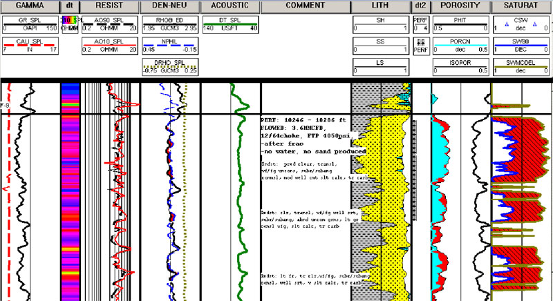
Figure 1. Wireline data on left side of COMMENT track. Probabilistic formation evaluation modeling on right. The red diagonally shade area between the log derived and core derived saturation curves highlights the differences.
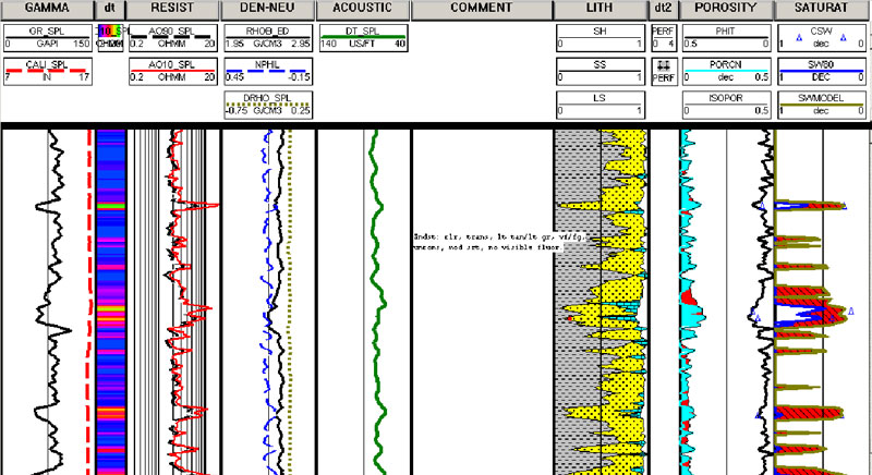
Figure 2: This log plot shows the integration of the core data with the formation evaluation result..
Learn More
For more, contact the well log data experts at Wallace International, LLC.